 Spaces & Places
Compass Navigation
In a modern age with technology at our fingertips, old-school skills like compass navigation seem like an antiquated pastime. I must confess that I overly rely on AllTrails GPS during my backcountry hikes, especially ones that involve a significant number of trail intersections. In fact, I can honestly say that I’ve never felt the need for a compass and topographical map during my many outdoor adventures. Yet on a whimsical last-minute decision, I decided to take REI’s orienteering course at Rock Creek Park a few weekends ago. It was an early start to the day, and I bundled up in layers to beat the overcast skies and significant wind chill. Armed with my compass, thermos of tea, and enough snacks to feed an army, I ventured out.

Our instructor, Dave, had a well-organized set-up outside of the Rock Creek Nature Center. There were maps galore, alongside a whistle, two types of compasses, and a ruler. We made introductions and then set to work, spending the first two hours simply understanding the basics of orienteering and land navigation.

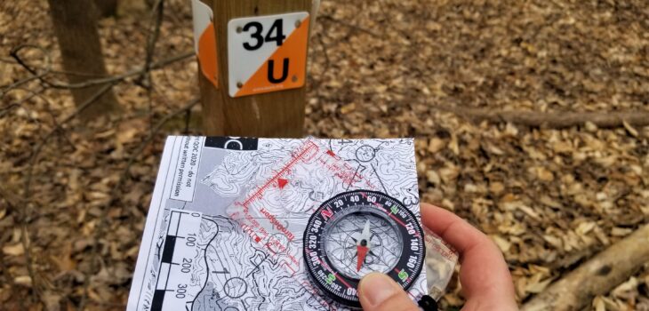
The best part of the class was when we were teamed up and got to set out on the land. Working collaboratively sans our smart devices was a new experience and surprisingly fulfilling. I never knew how satisfying it was to navigate towards a goal using just my brain, compass, and map. I learned a lot about reading the land instead of relying solely on the familiar dashed-line on maps (which indicate the trails).

The following weekend, I set out to Fountainhead Regional Park, attempting their intermediate navigation course which is permanently set up. I didn’t quite know what to expect. Yes, the orienteering part comes naturally to me, but I knew that there are quite a few variables that come into play when understanding the landscape and how to navigate it. Needless to say, it was a very successful adventure. It took longer than I thought, with lots of off-trail slipping/sliding as well as some backtracking, but I found each of the markers with a renewed sense of confidence.

Next time I do backcountry treks in the middle-of-nowhere, I will now have a fallback method of knowing where I am and how to get to where I want to go.
(Don’t worry, AllTrails, you’re still my fave.) ❤